by John Boettcher and Richard Murray
Introduction
There are 28 miles of trails in the open space areas of Webster, NY. Most of these trails were made and are maintained by Friends of Webster Trails (FWT) which is a volunteer organization serving under the Webster Parks and Recreation Department. The trails need attention in order to keep them accessible and safe. Knowledge of the relative use of the trails would help prioritize regular maintenance and funding. This knowledge is also useful when applying for grants in support of the trails.

Equipment and Use
After some research, FWT purchased a TTC-4430 Trail Counter from Diamond Traffic Products of Oakridge, OR. This device uses the interruption of an infrared beam in order to count trail users. No photography is associated with the counter. Control of the counter is done using a magnetic key which is swiped over certain positions on the unit in order to set the unit up and access the data.
The unit is mounted to a tree adjacent to the trail and aimed at a reflector on the opposite side of the trail. These are positioned to result in the infrared beam being between waist and chest high. Details about the counter, its setup on a trail, and the output can be found in the appendix of this report. The results in this report are for one week of observation unless otherwise indicated.
Results and Discussion
Finally, Table II shows the one week count results and the starting date for the count.
Figure 1: Locations of the trails in the town of Webster
Table I – Alphabetic List of Webster Trail Abbreviations Used in this Report.
| Abbreviation | Trail Name |
| BST | Bird Sanctuary Trail |
| CT | Chiyoda Trail |
| FMCP | Four Mile Creek Preserve |
| FPNT | Finn Park Nature Trail |
| GBWP | Gosnell Big Woods Preserve |
| HBT | Hickory Bark Trail |
| HRFWF | Herman Road Forever Wild Forest |
| HT | Hojack Trail |
| JUNT | John Ungar Nature Trail |
| MAJNP | Michael A. Johnson Nature Preserve |
| MTC | Midnight Trail Connector |
| MT | Midnight Trail |
| SRNP | State Road Nature Preserve |
| VHNT | Vosburg Hollow Nature Trail |
| WRNP | Whiting Road Nature Preserve |
Table II: one week count results and the starting date for the count
| Abbreviation | Trail Name | Location Detail | Start Date | 1-week Count |
| BST | Bird Sanctuary Trail | 12/16/2023 5/5/2025 | 926 726 | |
| CT | Chiyoda Trail | 5/28/2024 | 726 | |
| FMCP | Four Mile Creek Preserve | Blue Trail start Blue Trail start Red Trail | 11/14/2023 8/14/2024 7/2/2025 | 567 578 409 |
| FPNT | Finn Park Nature Trail | 5/21/2024 | 261 | |
| GBWP | Gosnell Big Woods Preserve | entrance entrance woods field | 10/24/2023 8/21/2024 8/28/2024 9/4/2024 | 897 1164 376 1072 |
| HBT | Hickory Bark Trail | 6/12/2024 6/19/2024 | 71 78 | |
| HRFWF | Herman Road Forever Wild Forest | 11/7/2024 7/10/25 | 367 330 | |
| HT | Hojack Trail | east of Sexton Park east of Klem Rd. east of Drumm Rd. | 12/8/2023 11/30/2023 7/2/2025 11/23/2023 9/12/2024 | 276 239 674 519 743 |
| JUNT | John Ungar Nature Trail | 5/14/2024 | 111 | |
| MAJNP | Michael A. Johnson Nature Preserve | 05/23/25 | 63 | |
| MTC | Midnight Trail Connector | 11/7/2024 11/15/2024 7/18/25 | 400 344 477 | |
| MT | Midnight Trail | 7/8/2024 | 191 | |
| SRNP | State Road Nature Preserve | 11/20/2024 8/5/25 | 80 63 | |
| VHNT | Vosburg Hollow Nature Trail | intersection Hojack entrance | 6/5/2024 6/16/25 | 309 145 |
| WRNP | Whiting Road Nature Preserve | blue trail north blue trail south blue trail interior | 11/7/2023 10/31/2023 9/19/2024 | 451 802 179 |
In addition, a 30-day count of the Hojack Trail was conducted on 4/8/2025, with a user count of 1684, and a 30-day count of Whiting Road Nature Preserve Blue Trail was conducted on 9/27/2024, with a user count of 3584.
We have chosen one week as the count time for most of these initial studies. The counter provides hourly data also which could be used to examine things like AM versus PM and weekend versus weekday use of the trail. These might be the subjects of additional reports. Note the results of this study were obtained over a period of nearly two years. The one-week counts range from 70 to 1200. If we translate this into yearly use, we get the numbers like 3,600 to 62,000.
Even allowing for the fact that, in some instances, the counter is recording both coming and going of a visitor, the counts are large, and the numbers might be suspect. However, repeat measurements for HBT are similar and so are those for MTC. Additional support is provided by the 30-day studies at HTN and WRNP BS which scale to weekly results. Perhaps a different season will give lower numbers, but the counts for FMCP, GBWP, and HTN, more than six months apart are all big. One must accept that the counts given represent the traffic that the trails are experiencing.
For two of the preserves, we examined the traffic into the preserve versus that on one of the trails in the preserve. In the case of GBWP, we have 897 and 1213 for the entrance but only 376 going into the Big Woods trail of the preserve compared to 1134 for the Big Field. This suggests that less than half the folks using GBWP are using the Woods. Most appear to be using the Field. In the case of WRNP, we have counts of 451 and 802 for entering the preserve using the north and south Blue trail entrances. These are the only two entrances to the preserve from the parking lot. We measure only 186 for the middle of the Blue trail. This suggests that the Blue trail is being used to access the other trails of WRNP and not the Blue trail itself.
Another study looked at FMCP where the Blue trail is the only entrance from the parking area with counts of 567 and 578. Further east it connects with the red trail and the count (409) is not too much different than those of the Blue suggesting that both trails are used by visitors.
So, who is using the trails? The counter can’t tell us. Observer counts of the different users must be obtained. This is tedious and only a brief survey was done at WRNP BS. Different days (weekday, weekend) and different times (morning, afternoon) were chosen with the results shown below in Table III. There were four categories of users. Of the major users, 50% were hikers, 30% dog walkers and 20% bikers. This might be much different for other locations.
Table III Observer Data WRNP – Blue Trail South at Parking Lot
| Date/Time | Total | Dog Walker | Hiker | Biker | Hunter |
| TU 10/1 (1:11-3:10 pm) | 16 | 5 / 31% | 8 / 50% | 3 / 18% | |
| SA 10/12 (9:40-11:40 am) | 44 | 14 / 32% | 21 / 48% | 7 / 16% | 2 / 4% |
| SU 10/27 (1:00-3:00 pm) | 46 | 9 / 20% | 34 / 74% | 3 / 6% |
Trail Maps with Approximate Counter Locations and Detailed Discussion
What follows are graphs showing the counter locations used for the various trails. This is accompanied by trail description and perhaps some discussion of the counter results. The entries are in alphabetic order based on the trail abbreviation.
Bird Sanctuary Trail (BST)
This trail connects the Chiyoda Trail on the east at 250 with the Hojack Trail on the west just across Orchard Street. We got 926 and 726 counts for one week. This is a route for hikers to get from Parks and Rec to Sexton Park and the Hojack trail.
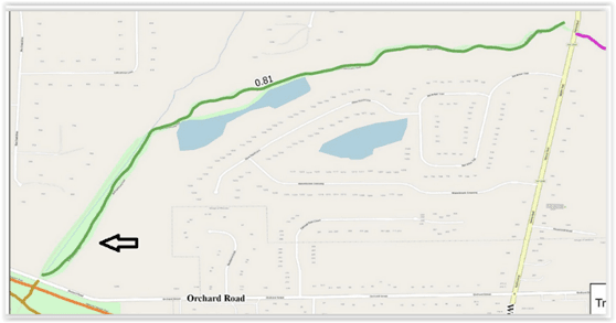
Chiyoda Trail (CT)
This is a very short trail connecting the Parks and Rec paved trail to the east with the Birdsong trail to
the west across Rt. 250. The count of 726 seems high but we have reason to believe it is accurate. It
might reflect use of the trail by programs at Parks and Rec.
Four Mile Creek Preserve (FMCP)
The counter was deployed on the Blue trail just after the first bridge after exiting the parking
lot. The two measurements are pretty close even though 9 months apart (567,578). At a later date, the counter was set up on the Red trail just after the big bridge (409). This count suggests that most folks take in both the Blue and Red Trails on their walk.

Finn Park Nature Trail
The Finn Park Nature Trail is located north of Rt. 104 and extends from Maple Road on the west to Gravel Road on the east and until recently was accessed only from Maple Road with parking at the Liberty Lodge. We measured 261 for the week. We suspect that a good part of the traffic comes from the neighborhood bordering the park to the southwest and having access trails.
Gosnell Big Woods Preserve
We measured usage of this preserve by choosing a position north of the parking lot at Vosburg and Drumm Road but before any side trails are available (897, 1164). Additional measurements were made in the southwest corner of the Big Field (1074) and the entry to the Big Woods (376). The similarity of the count near the parking area and that of the Field suggests that most visitors are using the Field rather than the more challenging walking in the woods.
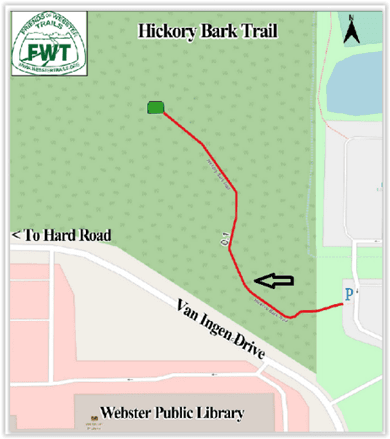
Hickory Bark Trail
This trail is across the road from the Webster Park Library and is accessed from a parking lot to the east. Most of the trail is on boardwalk and ends at a large platform area. Light traffic was measured on two adjacent weeks with very similar results (71, 78).
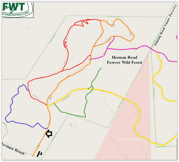
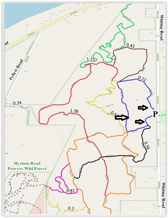
Herman Road Forever Wild Forest
This series of trails connects to the WRNP and is a relatively new preserve. We chose to measure traffic at a site close to the parking lot on Herman Road and just before any branching for side trails (378 (11/24)).
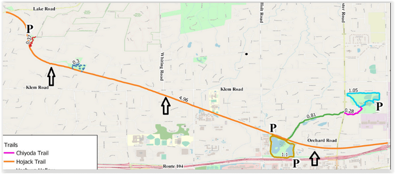
Hojack Trail
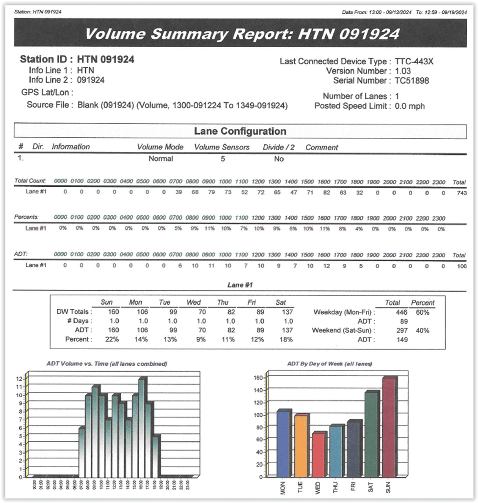
This is the oldest and longest trail for FWT. Indeed, the name of the organization at its inception was the Friends of the Hojack Trail. It is 5 miles long, extending from Philips Road in the Village to Lake Road. Lots of history associated with the trail. Its length and multiple entry points suggested the use of several locations. One, HTN, was located just east of Drumm Road (GPS 43.235804, -77.490374) with counts of 519 and 743. There was also a 30-day study of this location with 1684 counts.
Another, HTK, was just east of Klem Road (GPS 43.229785, -77.468743) with counts of 239 and 674. The big difference between these two counts we believe to be due to tree clearing activities of Rochester Gas and Electric.
Finally, one, HTE, just east of Sexton Park with counts of 276. The difference in the numbers suggests that different groups are using the different sections of this long trail. This might reflect parking access, access to nearby trails, natural beauty, or user proximity.
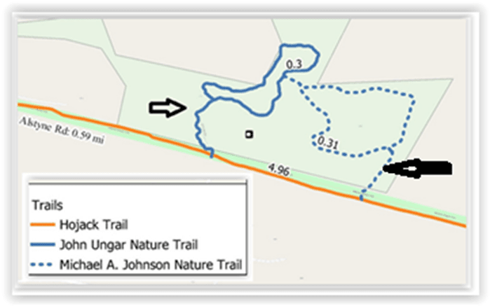
John Ungar Nature Trail and Michael A. Johnson Nature Preserve
These two connected trails are accessed from the Hojack Trail about midway between Van Alstyne and Drumm Roads. One can make a nice figure 8 hike by taking in both trails at one outing. Very nice hardwood forests. We measured the access point at John Ungar (111). This location is not used by bikes because of the stairs leading to the Hojack Trail. At a later date we placed the counter near the entrance of the MAJNP with 63 counts recorded. Both of these counts are much less than those obtained on the adjacent Hojack Trail.
Midnight Trail
This trail is located in the southern part of Webster Park. The southern portion of the trail is bordered by private property on 3 sides. The trail can be accessed from the Whiting Road parking lot using the Midnight Trail Connector and trails established in Webster Park. We found moderate use of this trail (191).
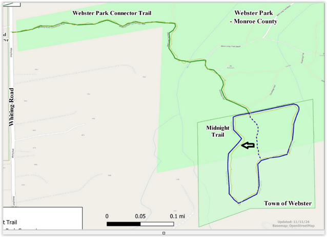
Midnight Trail Connector
This trail connects the parking lot of the Whiting Road Nature Preserve to a North-South trail in Webster Park which leads to the Midnight Trail. The traffic was measured on two adjacent weeks giving similar numbers (400, 344). A subsequent count gave 477 in reasonable agreement.
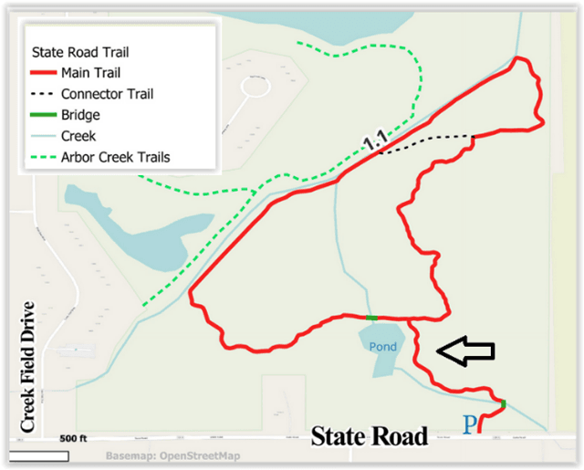
State Road Nature Preserve
One of the newest trails in the system. It is accessed from a parking area along State Road just west of Salt Road. There is still work to be done in this preserve. We measured light use of the trails (80, 63).
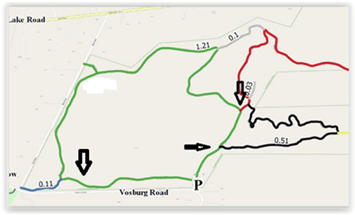
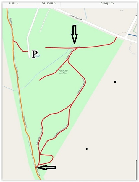
Vosburg Hollow Nature Trail
This is one of the oldest trails in the system. It is bordered by the Hojack Trail (actually a neighbor’s driveway) on the west and Vosburg Road on the North. Shipbuilder’s Creek runs through the center of the preserve. The parking lot is behind a sewer pump station. Moderate use of the trail (309) from the trail intersection nearby. ocation. Use from Hojack Trail access was 145.
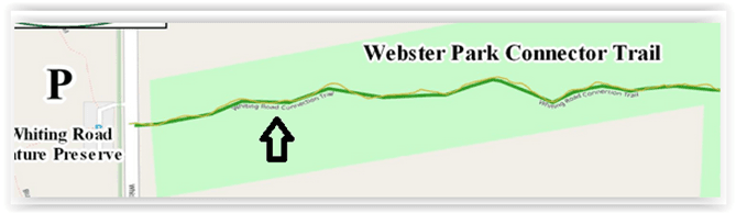
Whiting Road Nature Preserve
Main access to the several trails in this preserve is from the parking lot on Whiting Road. The Blue trail has a north and a more popular south exit from the parking lot and we measured traffic on both (Blue north 451 (11/23), Blue south 802 (10/23). We also measured traffic on this trail away from any junctions (Blue mid 186 (9/24). The much lower count for the mid-trail location indicates use of the Blue trail to get to other trails rather than to use the Blue trail itself.
Appendix
Setup of the Trail Counter and Treatment of Results
The TTC-4430 is mounted to a tree using three large screws terminated with threaded bolts. The unit is positioned, and holes are drilled in the tree for the screws. It is important that these screws be fairly parallel in order to accept the counter. We found it difficult to hold the somewhat heavy counter in position with one hand while using a drill with the other and obtain this parallel requirement. A light mockup of the counter was devised which also guided the drill to parallel positions.
Once the mounting screws were in place in the tree, the counter was set on them and the fine positioning done using nuts and washers on the end of the screws. The unit was then secured with additional nuts.
This “aiming” is best done by a crew of two with one person adjusting the unit and the other person holding a temporary reflector. To aide in the aiming, the unit produces a high-pitched tone when it does not receive the reflected beam. The temporary reflector is used to find where the emitting beam is currently aimed, and the unit is adjusted until the beam falls on the mounted reflector which is set at waist level on the trail. Once the unit is setup for an area the trees used, and the actual holes employed are marked. Repeat measurements, when done, are done at the identical location.
Once set up, the unit is instructed to start counting with the number of beam interruptions each hour stored. This continues for a count period of one week. At the end of that time the total number of counts was read using a magnetic key to activate the display. Following this, the hourly count can be acquired by swiping the key over the unit. There are 168 hours in a week, so this is a lengthy and somewhat boring process. The hourly counts are entered into a spreadsheet. Keeping track of the day and hour when the counting started allows one to determine morning versus afternoon use and weekday versus weekend use which was thought desirable but will not be further explored in this report. A portion of a representative spreadsheet is shown below. Not all the data is shown in the spreadsheet, but the plot (in 2 hr. increments) does.

After a year of use, the unit was sent back to the manufacturer for an upgrade that would allow the data to be readily downloaded in the field to a computer. The accompanying proprietary software (Centurion Parks) also acquired keeps a database of locations and the total counts for a week along with hourly count statistics and daily traffic. An example is show below. The graphs comparing activity for the hours as well as days of the week are nicely presented. The hourly data is saved but not plotted as with the previous method. We are most interested, at present, in the total counts for the week.
Centurian output for Hojack Trail North 091924
There was correction applied to some of the counts. Weather events can lead to very high counts due to rain or debris interrupting the beam. These were deleted and the count for the period set to zero. Also set to zero were counts during the night. We attribute most of these to deer activity. Finally, there were some high numbers for which we have no explanation, and these were zeroed also.
Acknowledgements
The authors wish to thank the Board of FWT for their support of this study. Thanks also to Chris Bilow, Commissioner of Webster Parks and Recreation, for permission and guidance to do this study.